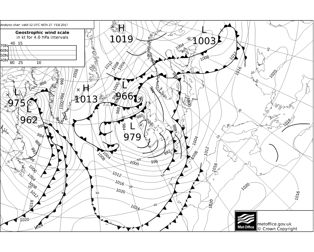
UK meteorology

Norwich showing 59mph gusts, and that's in a valley at the confluence of two rivers! Weybourne on the North Norfolk coast has had an 80mph gust, which must be the highest in a few years.
63mph now showing for Norwich; probably similar or slightly higher here. East Coast Mainline is shut between London and Doncaster. As the centre of Doris moves out into the North Sea, the East Midlands, northern East Anglia (i.e. me) and Lincolnshire are seeing the strongest gusts.
 
Gusts at 2.50 p.m. in kph:
58aefa15468f1_GustsUK14_50.png.5b9e2147eddf685748e0d6e0da5c3cea.png
 
Doris has now left the UK. Tomorrow will be chilly and blustery in most areas; over the weekend the most significant weather problem will be a rapid snow melt in parts of Scotland and possible surface from heavy rain in western areas of the UK.
 
Over the next couple of weeks, the predominant pattern seems to be unsettled but relatively mild. Next weekend may be particularly stormy and potentially colder in the north with snow, but most areas, even the south-east will see significantly more rain than in any period of equivalent length so far in 2017.

EDIT - that pragraph was based on yesterdays' model outputs. Todays suggest that the jet stream will be track broadly west-east (zonal) but further south than of recent. This would be more likely to allow colder conditions further north, especially as the tropospheric jet is likely to be separated from the polar vortex by a wedge of higher pressure to the north of the UK and extending through Iceland towards the southern tip of Greenland.
 
Last edited:
There is a Met Office warning for tomorrow and Monday for wind affecting north-east, central and southern Scotland, north-west England and the far north-west of Wales:

Issued at:
18:04 on Sat 25 Feb 2017

Valid from:
11:00 on Sun 26 Feb 2017

Valid to:
06:00 on Mon 27 Feb 2017

A small area of very strong winds is likely to move northeastwards over parts of the northwestern half of the UK. The area of strongest winds will arrive over northwest Wales late on Sunday morning and clear the northeast of Scotland on Monday morning.

For many a short period of gusty winds are likely with speeds perhaps reaching 70 mph in exposed locations whilst inland parts are more likely to see isolated gusts of 50-60 mph.

Some disruption to transport is possible. Heavy rain may also prove an additional hazard.

An area of low pressure is expected to begin developing to the west of the Republic of Ireland on Sunday morning before moving northeastwards across Scotland. This will generate some very strong winds to the south of the low centre. However there is a lot of uncertainty over the exact track and depth of this system and therefore the strongest winds.
 
This morning's models suggest a continuation of the current unsettled conditions, with a southerly-tracking jet bringing a series of Atlantic depressions across the southern and central parts of the UK, with colder air in or close to central and northern Scotland for the next few days, until, at the weekend, a ridge to our east seems to bring us a more south-westerly or southerly flow, lifting temperatures from the south and, possibly, indicating a weakening of the zonal jet into next week. This may well allow warmer and more settled springlike conditions to develop, although there appears to still be a chance of something colder.
 
Last edited:
This morning's models suggest a continuation of the current unsettled conditions, with a southerly-tracking jet bringing a series of Atlantic depressions across the southern and central parts of the UK, with colder air in or close to central and northern Scotland for the next few days, until, at the weekend, a ridge to our east seems to bring us a more south-westerly or southerly flow, lifting temperatures from the south and, possibly, indicating a weakening of the zonal jet into next week. This may well allow warmer and more settled springlike conditions to develop, although there appears to still be a chance of something colder.

Dude, cut to the chase. What's it going to be like on 15th March? Because that's when the trout fishing season starts.:confused:
 
Dude, cut to the chase. What's it going to be like on 15th March? Because that's when the trout fishing season starts.:confused:

Where are you referring to? I'm presuming somewhere in the UK; if that's the case, it could be rather cold; the American GFS model is showing a possible northerly blast with high presure ridging in the Atlantic; the Met Office's long-range discussion also suggests this as a possibility, suggesting that their in-house long-range models (mainly the GLOSEA5 model) are seeing indications of blocking.
 
Last edited:
Where are you referring to? I'm presuming somewhere in the UK; if that's the case, it could be rather cold; the American GFS model is showing a possible northerly blast with high presure ridging in the Atlantic; the Met Office's long-range discussion also suggests this as a possibility, suggesting that their in-house long-range models (mainly the GLOSEA5 model) are seeing indications of blocking.

Indeed I am; north Devon to be precise. I have to say that I'm less impressed by your forecasting.:confused: For the last few years I've been in the River Taw on 15th March and have been unable to feel my feet after 30 minutes, emerging after a couple of hours with the size of my wedding tackle reduced to that of a Chinese mouse. I can still remember the year before last when a hailstorm drove me from the river at lunchtime...
 
Nesh this morning and must have dropped cold rapidly - there were raindrops frozen to the windscreen. Beautiful crisp, clear sunny morning my absolute favourite sort.
It was pretty cold here yesterday, Count, and I don't think it's much warmer today. We seem to be in a north-westerly flow at present with troughs and occlusions swinging across much of the country bringing showers.
Indeed, for the nearest amateur weather station to my location that's available on the Weather Underground site (https://www.wunderground.com/) shows the temperature as 5.3C, with a dewpoint of 2.2C (hence relative humidity of 83%) and a windchill of 4.6C.
 
Back
Top Bottom