
OP
- Messages
- 6,299
- Location
- Norfolk, England
- Thread Starter
- #609
Finally for today, here's Liam Dutton's view:

Odds and sods of rain here as well.Today is certain rain continuing from yesterday and through the night ...
JohnnyO. o/
Between 16:00 Tue 18th and 23:55 Tue 18th
Thundery showers are expected to push north across southern parts of the UK through Tuesday evening. Although many places won't see these showers, there is a chance of localised flooding of homes, businesses and susceptible roads. Frequent lightning may be an additional hazard with possible disruption to power networks. Similarly, but very locally, hail may cause impacts.
I suspect you're too far north for tonight's risk, Colum. You might see some rain, but it probably won't be storm-like until tomorrow.I was just thinking of chucking some grass seed on the lawn on the strength of that warning...
Storm & Convective Forecast
Issued 2017-07-17 22:18:34
Valid: 18/07/2017 06z to 20/07/2017 06z
DAY 1 & 2 CONVECTIVE OUTLOOK - 18TH / 19TH JULY 2017
Synopsis
A negatively-tilted long-wave upper trough extending SE from S Greenland toward Bay of Biscay will approach to W of Ireland on Wednesday. Low to mid-level flow will back S to SEly ahead of trough and will draw in a very warm / moist and increasingly unstable high theta-w plume north out of France later on Tuesday and through Wednesday, as a surface low drifts north out of W France / Biscay. Elevated thunderstorms on the northern edge / warm front of the plume are likely to develop Tuesday evening/ night and move N across England and Wales, reaching Scotland by late Wednesday morning. Hot and humid airmass in wake of these storms across England and Wales may support further storms in the afternoon
DAY 1 CONVECTIVE / STORM FORECAST – TUESDAY 18TH JULY 2017
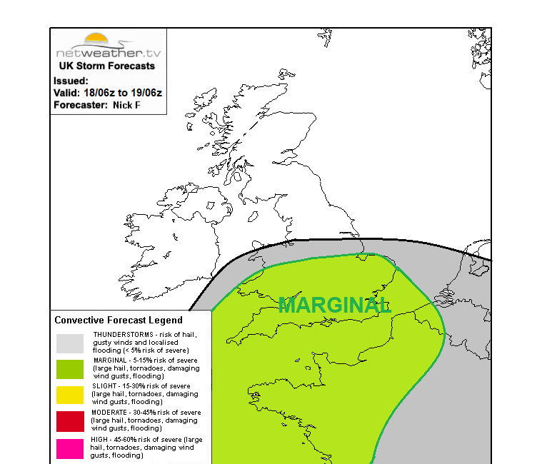
VALID TUES 18TH 0600 TO WEDS 19TH 0600
Areas concerning … WALES, S ENGLAND, MIDLANDS, E ANGLIA …
Threats …Flash-flooding, frequent cloud-to-ground lightning, Hail
… Summary …
Isolated to scattered thunderstorms, locally strong, will bring a risk of intense downpours, frequent lightning and isolated hail to parts of southern Britain from Tuesday evening and overnight into Wednesday morning.
… Discussion …
Theta-w plume spreading north out of France Tuesday evening / night will be characterised by steep mid-level lapse rates associated with elevated mixed layer (EML) aloft originating from SW Europe. This will bolster mid-level instability in the warm conveyor spreading north from France later, with lift of warm conveyor aided by a low-amplitude shortwave trough moving NE ahead of large scale upper trough to the west. This instability and lift supporting development of isolated to scattered elevated storms spreading north with the northern edge of the advancing plume. Scattered storms initially developing and moving north across SW England this afternoon and evening, forming clusters and then moving north through parts of Wales and the W Midlands this evening and overnight. Storms are likely to develop and drift north further east during the evening and overnight across parts of central-S and SE England too – though coverage here maybe more isolated as per recent model runs.
Southeasterly low-level flow veering and strengthening to S or SWly aloft should result in 30-40 knts of effective shear … which combined with MLCAPE values of 500-1000 j/kg … will support organised clusters of thunderstorms – which may grow upscale and merge into one or two small convective complexes. Have issued a MARGINAL threat for intense/torrential downpours producing 20-30mm per/hour locally leading to flash-flooding. Frequent cloud-to-ground lightning may accompany stronger storms. Also there may be isolated incidences of large hail and strong wind gusts.
--------------------------------------------------------------------------------------------------------------------------------------------------------------------------------------------
DAY 2 CONVECTIVE / STORM FORECAST – TUESDAY 18TH JULY 2017
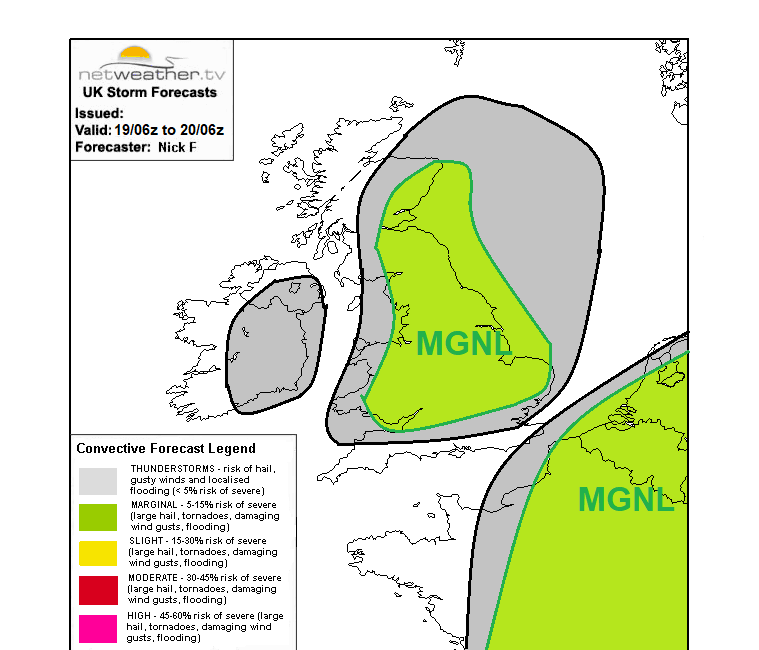
VALID WEDS 19TH 0600 TO THURS 20TH 0600
Areas concerning … ENGLAND, WALES, S and E SCOTLAND:
Threats …Flash-flooding, frequent cloud-to-ground lightning, large hail, gusty winds.
… Summary …
An area of scattered thunderstorms, locally strong and forming one or two storm complexes, will spread north across England and Wales Wednesday morning, before reaching S and E Scotland in the afternoon, bring a risk of intense downpours, frequent lightning and isolated hail. In the wake of these elevated storms, a very warm or hot airmass will support further development of isolated thunderstorms across England and Wales in the afternoon.
… Discussion …
… England and Wales …
Elevated thunderstorms are likely to be ongoing at breakfast time on Wednesday, spreading north across England and Wales during the morning. These storms will continue to bring a threat of flash-flooding and frequent cloud-to-ground lightning, though hail threat likely diminished.
In wake of these elevated storms drifting north, a warm and humid airmass will be in place which, with surface heating in increasing sunshine by the afternoon, will become unstable with CAPE values of 500-1000 j/kg inland widely, with E Midlands and E Anglia forecast values of 1000-1500 j/kg by GFS. Despite a lack of focus for lift to trigger storms and weak deep layer shear, surface heating and strong instability should support scattered thunderstorm development late morning onwards through to the evening, mainly N of M4/London – where SWly flow will not be modified by maritime influence so much. Strengthening SWly flow aloft may allow storms to merge and organise into linear segments – with a risk of isolated large hail, given large CAPE values, risk of intense downpours leading to flash-flooding and also strong wind gusts.
… Scotland …
Elevated storms are likely arrive and track NE across southern and eastern parts later in the morning and through the afternoon before clearing in the evening. These storms may produce intense downpours leading to flash-flooding, frequent lightning and gusty winds.
Issued by: Nick Finnis
I was just thinking of chucking some grass seed on the lawn on the strength of that warning...

Flash flooding in parts of Cornwall, it did come down heavy!Very rare event to the west and now north of London; a Mesoscale Convective Vortex. It's essentially a Mesoscale Convective System (MCS), which in itself is a cluster of storms which can cover an area of 200 square miles, which starts rotating as though it was a miniature hurricane. It's immensely rare not just in this country but in Europe generally. Consider this an unsceduled 'lesson' post - here's the radar image from earlier when i was at its height:
Indeed, that wasn't this MCV but a more 'normal' cluster of severe storms.Flash flooding in parts of Cornwall, it did come down heavy!
Between 11:00 Wed 19th and 23:55 Wed 19th
Further, possibly severe, thunderstorms may break out again this afternoon and evening, probably focused over parts of northeast Wales, central and northern England. Some heavy, thundery rain may also spread into parts of southwest Scotland by this evening although the risk of disruption is lower here than further south. Although some places will miss the thunderstorms, there is a chance of localised sudden flooding of homes, businesses and roads. Frequent lightning and large hail may be additional hazards, the latter bringing potential for disruption to power networks. This warning has been updated to shrink the south of the yellow area (where the risk of disruption in now reducing) whilst also to extend it further north across northern England and into southwest Scotland. The end time has also been extended a little.