
OP
- Joined
- Saturday January 15, 2011
- Location
- Norfolk, England
- Thread Starter
- #433
There appears to be a rather complex set-up at present with two different possible evolutions beyond the middle of next week. After the Bank Holiday weekend (see video in previous post) it seems likely that the first half of next week will see high pressure in the northern North Sea moving west (retrogressing), such that, by the second half of next week, the high will be centred around Greenland. As this retrogression occurrs, a north-easterly is expected, which would bring cooler air but stronger sun, so actual temperatures at ground level would be variable for the southern half of the UK, with the warmest conditions in the far south-east. Further north and west, conditions may be more consistently warm but possibly cloudier. Where the doubt emerges is in the evolution next weekend - if the ridge associated with the retrogressed anticyclone (High) lies on a north-west to south-east axis, winds in the south east will be more easterly, bringing warmth (possibly high teens); if, however, the ridge is oriented north to south, it will lie to the west of the UK, leaving areas away from the far west in a cold and potentially pretty unsettled northerly flow.
EDIT: Further to the above, here is the view of an experienced Netweather member who posts model-based overviews (emphasis in bold is mine):
EDIT: Further to the above, here is the view of an experienced Netweather member who posts model-based overviews (emphasis in bold is mine):
Morning all
Didn't expect to have to scrape ice off the car this morning but this final hurrah of winter is now at hand and on its own way out to be replaced by, well, a confused weekend. Perhaps best in the north and east but the details still to be worked out.
Yesterday, the models were strongly in favour of a build of pressure to the NE gradually transferring to the NW over time but there were many permutations and much to resolve.
This morning's output takes us to the early hours of Sunday May 7th:
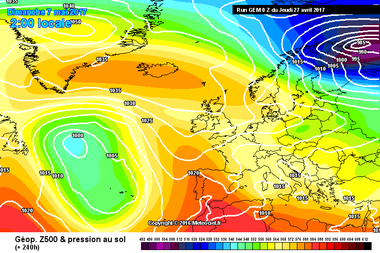
Starting with the GEM 00Z at T+240:
Quite a simple story this morning. After a brief unsettled hiatus through the early part of the coming weekend, pressure builds strongly from north and south on Tuesday and the northern HP becomes the dominant feature first to the NE of the British Isles and then retrogressing to be centred over Greenland but with a ridge SE back to the British Isles. The air flow over the British isles is sourced from a long way north so this would be a cooler NE'ly but the weather would be fine for most and the further west the better in terms of sunshine.
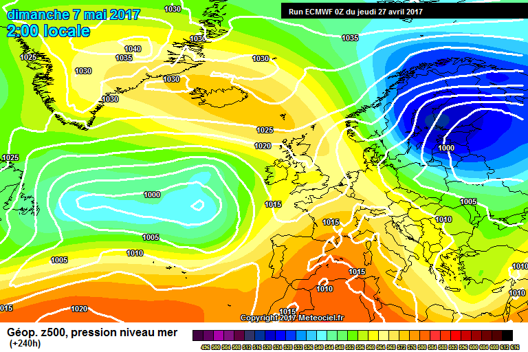
ECM 00Z at the same time:
Some subtle differences to GEM - note the orientiation of the Atlantic trough - but the net effect is much the same. The HP starts in the northern North Sea but retrogresses to Greenland with the ridge more ESWE and that means a more defined NE'ly for much of the British Isles sourced from some cold air over Scandinavia and NW Russia. Dry weather dominates the British Isles with the best of the weather in the west and north west.
GFS 00Z OP at T+240:
Subtle differences again starting with the Atlantic trough which is further south and with a different orientation to the GEM and ECM. The HP evolution is broadly similar though GFS creates a small LP to the far north which runs east into northern Scandinavia before sinking south. This cuts off the relatively warm E'ly and introduces a weak NE'ly flow but pressure falls across the south of Britain as LP moves NE from Biscay so by T+240 the south would be unsettled with rain or showers at times while the far north and north west holds on to drier conditions.
Little changes further into FI with pressure always high to the north and low to the south and the wind flow oscillating between a warm SE'ly and a cooler NE'ly. The south would be vulnerbakle to showers or longer spells of rain while Scotland stays largely dry.
The Control brings the trough up into the British Isles in furthest FI.
The 00Z GEFS at T+240 show strong agreement for the overall evolution and for strong HLB to the north and north west. The position and orientation of the trough has a number of variants but the majority produce a NE'ly flow of some degree.
In summary, while the details of the weekend may still need finalising, the trend to build strong heights to the NE early next week is confirmed this morning. All models take these heights toward Greenland though with varying orientation of the ridge. Some bring the ridge back SE over the British Isles keeping us broadly dry and fine while others keep the ridge further north allowing pressure to fall to the south and less settled conditions to encroach from the south and south west.
The net effect is, after a brief warmer E'ly interlude to swing winds to a cooler NE'ly direction.

")