UK meteorology

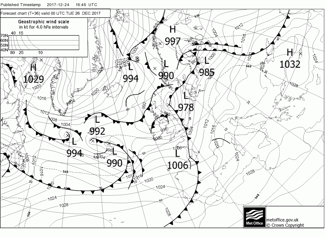
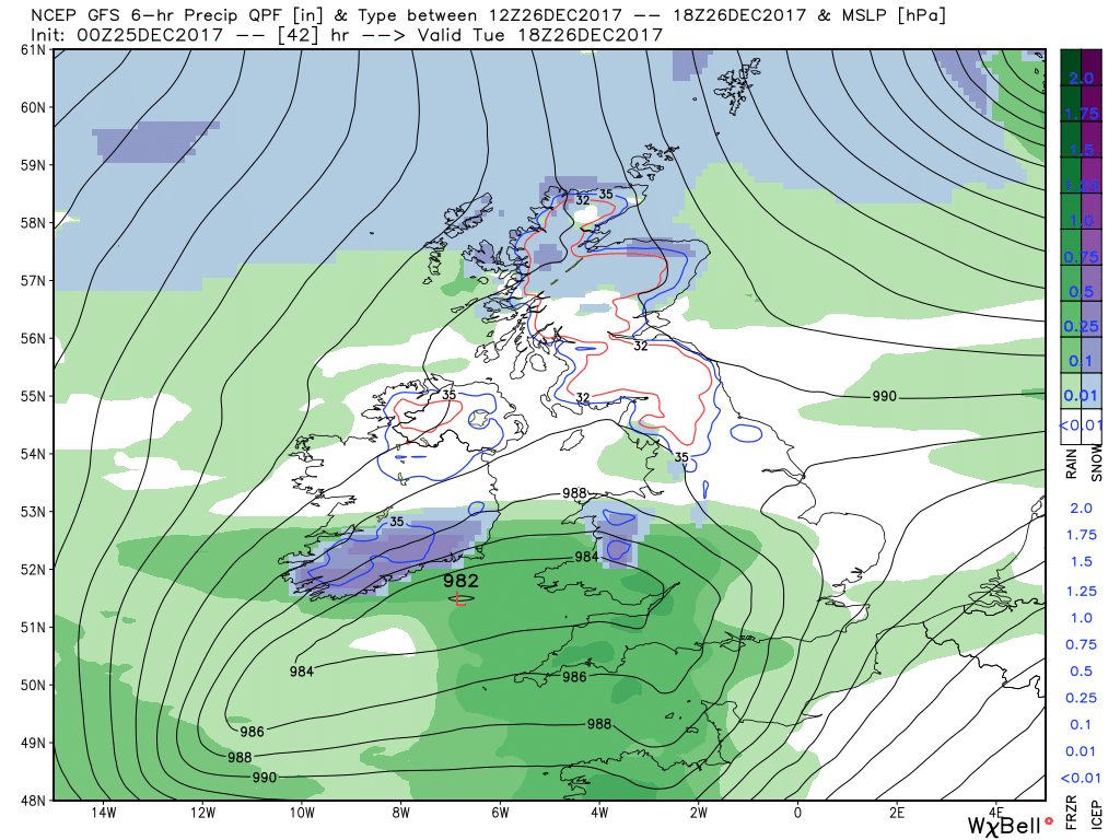
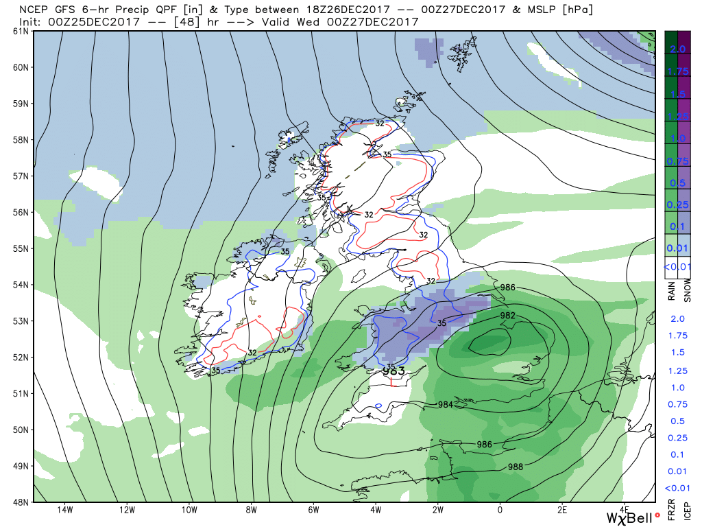
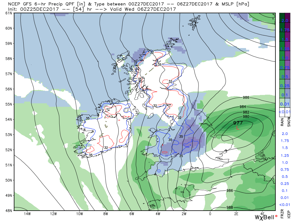
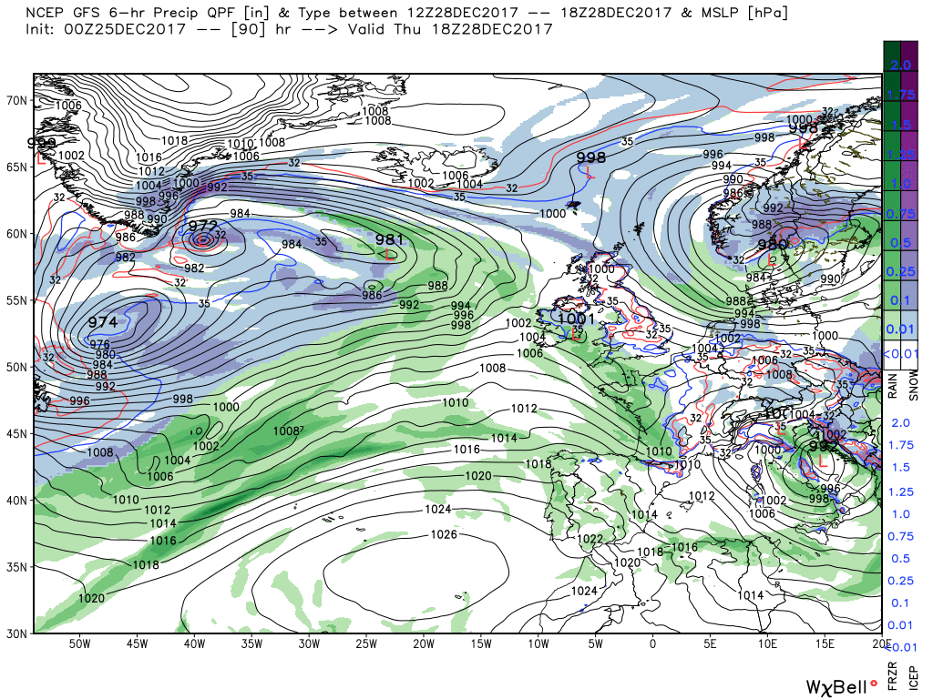
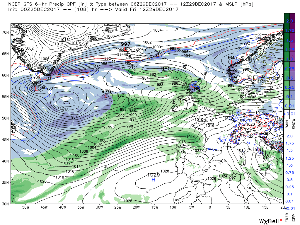
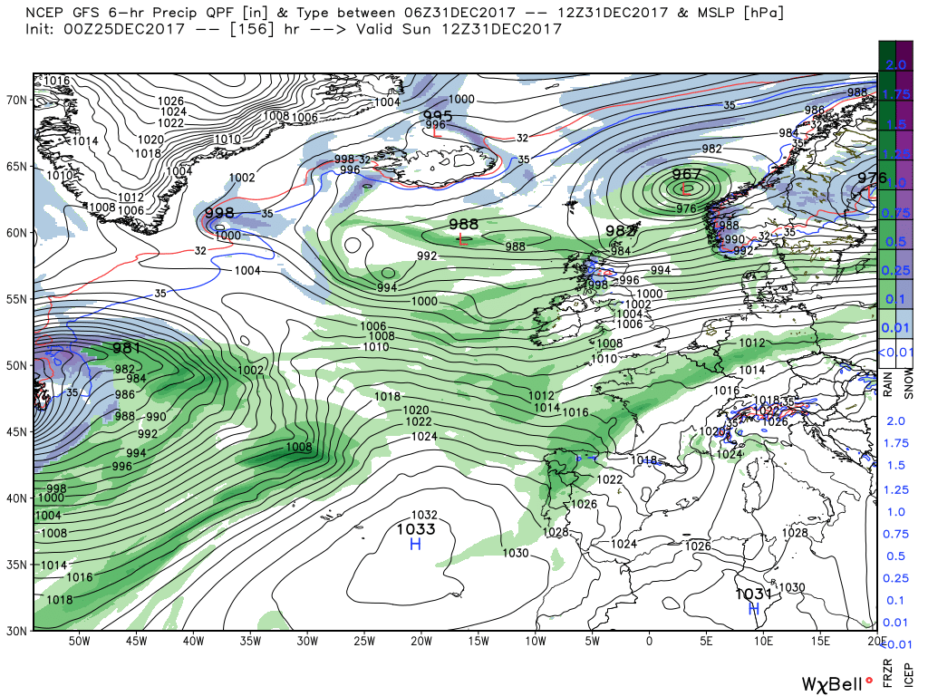
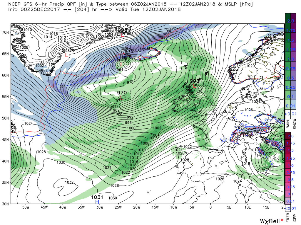
I won't be posting much here over the main festive period, though I will link one or two posts from the usual Netweather members. I'll check this evening as to whether the models are still showing an Atlantic storm for Boxing Day: I haven't checked since yesterday and 24 hours is a lengthy period of time in meteorology!
 
Although the following article is from the US, and refers to previous blog posts on the El Nino Southern Oscillation which I haven't linked previously, I thought I'd post it as it explains the Madden-Julian Oscillation (MJO). This has an effect on winter weather in the UK, with phases 7, 8 and 1 being most conducive to cold and/or snow via. blocking areas of High pressure in the mid-high latitudes of the Atlantic:

https://www.climate.gov/news-features/blogs/enso/what-mjo-and-why-do-we-care
 
Last edited:
Today's thoughts from the usual chap:
Today persistent rain over western Scotland will move south to cover N. Ireland and north west England whilst elsewhere a moist, freshening WSW airflow will persist with perhaps patchy drizzle in the west and temps a little above normal, Tomorrow the rain in the north will track east, possible some snow in eastern Scotland, whilst a front and rain will approach from the west and make inroads across Wales and the western half of England


The front duly clears the south east early Tuesday morning but the two high pressure cells, one in mid Atlantic and the other eastern Europe are beginning to amplify resulting in the upper trough in the vicinity of the UK being forced south and the wave depression forming out in mid Atlantic being forced south east by the strong low level jet running around the Atlantic ridge. The low duly arrives over Pembroke 984mb by 1800 Tuesday and six hours later is over Salisbury en route to the eastern Channel. This could well produce snow along it's N/NW flank across Wales and the southern midlands. As always to be sorted nearer the time.


The low quickly moves away east initiating a cold northerly regime over the UK on Wednesday and Thursday with perhaps some snow in the south east initially on Wednesday Meanwhile the Atlantic and frontal systems are trying to gate crash the party from the west but the upper trough to our east is not going anywhere fast as it continues to be blocked by the HP to the east and is actually in the process of deconstructing. Ergo any fronts are struggling to make any headway east and tend to dissipate before reaching our shores leaving the UK pretty much in a col by Friday 00. Quite chilly during this period with frosts.


But by Saturday the Atlantic does get the upper hand with a deep low south of Iceland and subsidiary lows tracking across Scotland and fronts and rain tracking east across the rest of the UK in a strong SW/W airstream with temps now way above average reaching 13C in places.


The ecm continues to want to form a little wave on Monday's front to the south west and tracks it across northern France Monday night/Tuesday morning whilst the front itself brings a fair bit of rain to England and Wales, It then proceeds to track the wave depression further south than the gfs and has it 984mb over Cornwall at 1800 on Tuesday. Isle of Wight by 00 and Kent by 06 Perhaps snow on the moors and the M4 corridor. Very knife edgy and the precise track of the low still up for grabs
 
Netweather's chief forecaster on Boxing Day prospects:
Not huge difference between the models with Boxing Day night's low track in the grand scheme of things given we are still a good 60hrs away, but the differences of 50+miles makes a difference to the northern/southern limits of potential snowfall on the northern flank and back edge as it clears east.

00z ECMWF, UKMO and 06z ICON furthest south at 00z Weds, taking low centre through the E Channel:

EC-Hi res UKMET-GICON

00z/06z GFS and 06z ARPEGE further north at 00z Weds, 06z a little further north than 00z GFS

06z GFS 06z ARPEGE

EPS mean and standard deviation shows the lower confidence around the track of the low too:


Be interesting to see where the models track the low on the 12z output, plenty of room for change in track with the low yet this far out. Like other have said, we may not no until later tomorrow or early Boxing Day on most likely track!
 
Just a quick Christmas Day post to quote our usual member:
Today heavy rain in N. Ireland, southern Scotland and northern England will turn to snow over the Scottish mountains later. Elsewhere England and Wales will be cloudy in the moist south westerly airstream with temps above average but later in the day rain will affect western parts as a front tracks east. This will clear the east coast by morning bringing sporadic rain to most places and some snow on the higher ground to the north,


Apart from wintry showers in the north of Scotland tomorrow will be a tad sunnier and crisper than of late but by late afternoon rain, and some snow on the Welsh mountains, will be into the south west as the wave depression approaches and is 982mb in the Celtic Sea at 1800. By 00 Wednesday it is over the east midlands with the main snow area N. Wales and NW midlands. By 06 it is 977mb in the North Sea with the main snow area Wales. the south west and the Midlands which then moves east. But this is still a long way from being set in stone so keep a beady on subsequent bulletins.


The low then continues east into southern Norway initiating a cold northerly over the UK for a couple of days but by late Thursday the UK is in a col as the next low and associated front approach from the west but with the wind abating a very cold day ensues with temps struggling to reach 4C and lower in some places. The front with perturbations duly crosses the country Friday morning bringing patchy rain and snow on the Scottish mountains and much warmer air with it Thus fairly windy in the westerly airstream over the weekend with patchy rain/drizzle but as mentioned much warmer air, albeit quite a latitudinal variation, with temps reaching 13C in places.


For the rest of the week the pattern amplifies somewhat but with a lot of energy leaving the eastern seaboard south of the cold trough still fairly mobile. Thus the alternate trough/ridge scenario is the order of the day, as the the warm and cold .cold air interacts so periods of rain (perhaps snow on the higher ground in the north) with drier interludes. Very windy at times with quite a spread of temps but generally around the average. But not to get too hung up on next week as this obviously will change.


The ecm has the low 982mb Celtic Sea to north Devon at 1800 Tuesday with much rain in south west.

By 00 it is along the M4 and at 06 Wednesday it is orientated Sussex to great Yarmouth.

For what it's worth the ecm is showing quite substantial snow falls for Wales and the Midlands with lesser amounts for counties in the south west
 
Usual member again:
Not to be spending too much time on today and overnight as this will be the subject of many more detailed posts here and in other threads. Suffice it to say today will start a lot drier and quieter with the odd shower, but more frequent and wintry in Scotland, but the depression and rain will affect the south west and Wales by early afternoon and then track east across central and southern England clearing the south east tomorrow bringing rain, sleet and snow on it's travels.

.

Thus late Wednesday the UK is very briefly in a cold northerly airstream before a much slacker gradient on Thursday resulting in a very cold day with temps struggling to reach 4C But things are afoot way out west with an intense upper trough south of Greenland that spawns a low in it's southern quadrant 995mb which quickly tracks ENE on a very strong jet and 'bombs' to be 945mb north west of Ireland by 1800 on Friday, Whilst this has been happening a wave and weak front has traversed the UK overnight Thursday.

#

Overnight the low moves across Scotland into the North sea with the associated front crossing the country accompanied by rain but perhaps in Scotland and the north significant snowfalls on the higher ground. But the key factor may well be the wind with westerly gales, perhaps severe in some places


The low quickly clears away to the east but now upper troughs are firmly in control to the west and the UK is in a brisk westerly airstream as another low 'bombs' and loiters in mid Atlantic. The front associated with this system impacts the UK on Monday bringing strong winds and quite likely gales with more rain which again could well fall as snow on the higher ground to the north. Best left here as I'm sure the detail will change in this mobile and quite complex pattern.


The ecm also dabbles with some explosive cyclogenesis albeit not quite the same scenario as the gfs but it does agree on some very unsettled weather.

Friday sees a very active front running east south of Iceland and then south over Ireland which quickly crosses the UK with patchy rain, perhaps snow on the higher ground to the north. From this point until Tuesday 00 the upper trough dominates proceedings in the eastern Atlantic resulting in a complex surface analysis which boils down to sundry systems affecting the UK, thus intermittent periods of rain, perhaps snow over the higher ground in the north, and very windy at times. Temps quite variable in this mobile pattern but varying around the average.

From this point renewed amplification occurs with the upper trough to the east disrupting south of the UK whilst the Azores HP ridges north to the west.but such is the energy leaving the eastern seaboard that by Thursday the ridge is flattened with systems once more racing east albeit now tending towards a N/S split.


His post this morning will be familiar to those who've read the two previous ones I've quoted:
Today any rain sleet and snow still around wil clear the south east leaving the whole country in a colder N/NW airstrean with wintry showers in the north and west with strong winds along the coast, possible gale force. Overnight the winds will slacken a tad but still fresh around the coast with showers but elsewhere clear and thus quite a severe frost. Tomorrow a cold day with still the odd shower but a front will approach the south west later bringing patchy rain with perhaps snow on the high ground.


Friday sees the aforementioned front tracking slowly north east whilst a wave that has formed on it slips across the Midlands 981mb at 1200. the combination of this could produce snow on the leading edge of the front particularly on the higher ground in the north and in Scotland. Meanwhile a low has formed off the south east coast of the US on the southern edge of the upper trough which is tracking quickly north east and 'bombing' as it goes and is in mid Atlantic 971mb at same time. It continues to move quickly north east and deepen and by 12 on Saturday is 948mb west of the Hebrides and it's associated front is clearing the UK having brought patchy rain and snow over the high ground in the north. But more importantly accompanied by strong winds with gales in the west, severe over Scotland.


Apart from some strong winds the low has dragged some warmer air in and by 12 Sunday the low is over southern Norway with the UK in a strong westerly flow with temps around average and showers along western coasts. But more disturbances are en route from the eastern seaboard and one such tracks across southern England Sunday.night/Monday morning bringing rain to the south


The low quickly clears and the Azores tries to ridge north east but now there is a major upper trough area to the west and north west with a sharp delineation between the cold and warm air noted by a 160 kt jet running SW-NE and by 12 Tuesday this is quite marked as weak fronts and strong winds suppress any attempts of the Azores to ridge.


So 30 hours later after the passage of another low across the south with more rain the surface wind veers WNW and the colder air makes some headway with gales along western coasts and wintry showers. Best left here but just to note this looks like being a windy period with the possibility of severe gales in some places.


Sadly, no ECM this morning thanks to a power supply problem to their supercomputer.
 
As usual:
Apart from Cornwall tonight will be clear with once again a severe frost in many places but by now there is heavier rain in the south west which will move northeast during the day but will fall as snow along the northern edge in Wales, the Midlands and the north and southern Scotland as it hits the cold air. Mainly on the high ground bur certainly at low levels as well.


The weekend continues with the unsettled theme as more frontal; systems traverse the country bringing patchy rain but probably snow in Scotland accompanied by some strong winds in the north. So by 12 Sunday we have the main deep depression south of Iceland with the subsidiary 972mb in the north North Sea and the UK in a brisk westerly. But by 1800 on Monday the main low has slipped across Scotland and a wave has formed west of Ireland and has tracked quickly across southern England bringing rain to Wales and the south. Equally quickly it carries on tracking east into Denmark briefly initiating a light northerly over the UK by 1200 Tuesday as the Azores high pressure attempts to ridge north east.


In fact it does succeed briefly and a fairly quiet 24 hours ensues but by Wednesday 1800 we arrive at an analysis that epitomizes the current set up. A major upper trough to the north west and the colder Pm airmass with the warmer air to the south west with a strong thermal gradient marking the boundary between the two. On the surface this translates to a deep depression 961mb north west of Ireland (explosive cyclogenesis) with the associated warm front and rain across western parts of the UK whilst the cold front trails from Ireland away to the south west.


The warm front duly crosses the UK with perhaps more snow in Scotland and briefly introduces much warmer air but by 1800 on Thursday the cold front is through and a much colder Pm airmass is over the UK with quite possibly gales in the north and wintry showers in Scotland, N. Ireland and the west coast.


Over the next 24 hours the main low drifts south east adjacent to Scotland which would if it verified, which of course it will not be. would bring blizzards and severe gales to Scotland. All the same it does illustrate that in this sort of set up some severe weather can quite easily occur and it pays to be vigilant.


The GEFS mean anomalies this morning still maintaining the unsettled theme bur also the ridging from eastern Europe into the eastern Arctic and thus perhaps a split flow in the eastern Atlantic.


He goes on to point out that the ECM is fairly similar.
 
There is a rapidly-changing and complex set-up for the next few days - the usal Netweather member has performed his usual analysis of today's early GFS and ECM outputs, but it's complicated:
Today some heavy rain with strong winds across England and Wales , particularly in the north and southern Scotland, where the rain is liable to fall as snow, particularly on the high ground. Clearer ib the south later but some wintry showers perhaps thundery. Overnight another frontal system tracks quickly through England and Wales bringing more rain and quite windy for a time whilst further north it remains clearer with frost as temps dip.


After some brief ridging on Saturday another intense little low which formed off the eastern seaboard has 'bombed' quickly north east on the jet and is 966mb over N. Ireland by Sunday 00. This will bring heavy rain to the north, and a fair whack of snow on the higher ground in Scotland as it quickly tracks into the North Sea.


But with the upper trough now centred to the NE/E other perturbations slip south east in the circulation after the passage of this low into Scandinavia and one such perhaps brings more snow to the Scottish mountains on Monday whilst at the same time another wave has tracked south east around a transient ridge en route to France which may just impact Cornwall.


Mean while another low that originated off the south east seaboard 48 hours earlier has tracked north east and deepened in mid Atlantic and by 12 Tuesday is 964mb SSW of Iceland with it's associated front is lying across western parts of the UK accompanied by more rain and strong gales force winds as it quickly traverses the UK. But to complicate matters another wave has formed on the front that impacts Scotland bringing more snow the Highlands.


By midday Wednesday the UK finds itself at the coal face of a quite complex pattern to the west. Essentially a cold trough down the eastern half of N. America with colder air in the west and north west Atlantic with a strong thermal gradient dividing it from the warmer air to the south west with the jet indicating this running smack bang over the UK. Ergo as can readily be seen on the surface analysis for that time the UK is at the sharp end of two 'feeds', and never the twain shall meet, so to speak. Thus there is a low to the NW of Scotland introducing more snow and an active front west of southern Ireland about to bring rain to the south west.


Who will win the battle of the airmasses.? Well there is a lot of energy being pumped north east and that low 999mb that can be seen on the front on the above chart tracks rapidly north east and deepens to be 972mb close to the Western Isles by 1800 on Thursday bringing more rain to England and Wales and gales and snow in the north, But as it tracks into the North Sea matters are further complicated by a tempory surge of the Azores HP to the west which forces the low south veering the wind northerly over the UK, Best left here.


The ecm haws been pushing the nor'easter storm for a couple of runs now which helps promulgate the mid Atlantic ridge late on otherwise no great surprises in the run, remaining unsettled with temps varying around the average but dipping below towards the end. The key factors are wind and rain.

 
Interesting, though slightly technical post from Netweather's chief forecaster on a pivotal period around 5th of January:
The 12z EPS control builds a surface high centred 1030mb between Iceland and Scotland as early as Saturday 6th Jan before the high relocates east to be centred over Scandinavia by early 2nd week of Jan. However, the control has the similar issue as the deterministic in dragging in mild air from southern Europe into the easterly around the low centred to the south of the UK. Ideally would want the low pressure to elongate further east across central Europe to prevent this.

However, we need to get down the route of pressure building close to northern UK then across Scandi first, the steps for this would likely be:

1. The eastern N America trough amplifying/digging south middle of next week in response to amplifying +PNA ridge upstream, this in turn amplifies a ridge over NW Atlantic

2. Further downstream response from the amplification of the flow over NW Atlantic is trough disruption close to the UK, as the jet dives SE toward Morocco.

3. A 'trigger' surface low then drops SE across UK which allows pressure to rise to the NW then N of UK

4. High to the north of the UK stays or drifts east over Scandinavia, a northesterly or easterly develops.

5. If we get as far as the above, then the question of how cold the NEly or Ely, depending on shape of high to the N and NE and shape of low over mainland Europe to the S and SE.
 
In addition to those thoughts, here's the usual post:
Overall picture with this morning's gfs, is unsettled and very windy at times

Today a front and rain, some snow on the higher ground, will track north east leaving clearer weather behind apart from the SW where it will remain cloudy. Quite windy in the south. This evening a new low 963mb will arrive west of Ireland and the associated fronts and heavy rain will start impacting the south west Overnight and through to morrow morning the low will move north east to eastern Scotland and the heavy rain, again with snow on the high ground, will also track NE and it also could become very windy over N.Ireland, northern England and Scotland. Clearer weather behind but blustery showers in the resulting south westerly winds that also introduce milder air.


By 0600 Monday the low has moved north east to southern Norway but lows are queuing up to the west where we have the not unfamiliar picture of energy sweeping out of the south eastern seaboard in the form of a strong jet that is the boundary between the warm and cold air. Thus on the surface analysis there is a low 976mb wst of Hebrides associated with the main trough to the north east and a wave forming on the front delineating the boundary already mentioned


By 12 Tuesday there is a deep low 967mb in mid Atlantic which started life a couple of days earlier at the base of the upper trough and deepened rapidly as it tracked north east. The front associated with this is down the Irish Sea with rain already affecting the western parts of the UK probably falling as snow over the high ground in Scotland.


The front quickly crosses the country leaving the UK in a strong westerly, which veers north westerly, and under a two pronged attack us a wave swings south east across the south west en route to France and the main low drifts east over Scotland.


From this point things start to get interesting. Another low has bombed up from the eastern seaboard and is 957mb in mid Atlantic with associated fronts affecting the western UK but at the same time amplification is occurring and the surging high pressure splits the upper trough creating a high cell in the Iceland area whilst to the east of the UK it will deconstruct.


The amplification of the Azores HP forces the main low to fill and track south east over the UK as the west-east momentum is disrupted but there is still a huge amount of energy exiting the eastern seaboard so the question is can the ridge withstand the pressure? Almost certainly not but best left here.


The ecm is a bit of a nightmare next week with a couple of deep depressions bringing rain and strong winds, perhaps severe gales at times. It also amplifies the Azores HP which forces the last low south east to fill over the UK but again it is transitory as the east bound energy overwhelms any amplification by the end of the run


Met Office have released an amber warning for the latest named storm tomorrow:
https://www.metoffice.gov.uk/public/weather/warnings#?date=2017-12-31
Amber warning details
Wind

Between 04:00 Sun 31st and 13:00 Sun 31st
Some very strong winds are expected over parts of Northern Ireland and southwest Scotland on New Years Eve. There will probably be some damage to buildings such as tiles blown from roofs, with flying debris likely with the possibility of injuries or danger to life. In coastal areas large waves are likely as well as beach material being thrown onto coastal roads, sea fronts and perhaps some properties. Longer journey times and cancellations are likely as road, rail, air and ferry services may be affected. Some roads and bridges are likely to close. There is also a good chance of power cuts and the potential to affect other services such as mobile phone coverage.

Yellow warning details

Wind

Between 02:00 Sun 31st and 15:00 Sun 31st
Some very strong winds are possible across Northern Ireland and then southern Scotland and the far north of England on New Years Eve. There is a chance of damage to buildings, such as tiles blown from roofs, with the potential for injuries and danger to life from flying debris. Large waves and beach material being thrown onto coastal areas could also be a hazard. Longer journey times or cancellations are possible as road, rail, air and ferry services are affected with the chance that some roads and bridges could close. Powers cuts may occur and other services such as mobile phone coverage may be affected.

Yellow warning details

Rain

Between 18:00 Sat 30th and 09:00 Sun 31st
Heavy rain is expected across much of southeast Wales, southwest England and parts of central and southern England from Saturday evening and overnight into Sunday morning. Bus and train services will probably be affected along with spray and flooding on some roads making journey times longer. Flooding of a few homes and businesses is also possible.

Yellow warning details

Ice

Between 15:00 Sat 30th and 10:00 Sun 31st
Ice will form on untreated roads pavements and cycle paths. In addition some snowfalls may affect higher routes later on Saturday night and into Sunday morning. Some longer journey times are possible as well as injuries from slips and falls on icy surfaces.
 
Oh dearie me, looks as if Storm Eleanor is set to give west Scotland a drubbing tonight. Batten down the hatches and don the oilskins I fear.

JohnnyO. o/
It's going to be further south, Johnny, affecting only the far SW tip of Scotland. To give you an idea of how far south the warning area has moved, I'm under it!
Regions and local authorities affected:
  • East Midlands
  • East of England
  • London & South East England
  • North East England
  • North West England
  • Northern Ireland
  • SW Scotland, Lothian Borders
  • South West England
  • Strathclyde
  • Wales
  • West Midlands
  • Yorkshire & Humber
Chief Forecaster's assessment
A deepening area of low pressure, now named Storm Eleanor, will track east across the centre of the UK. This will bring gales and severe gales to Northern Ireland and northern England late on Tuesday and overnight, clearing eastern England during Wednesday morning. The strong winds may clip southern Scotland, with continued uncertainty in the northern extent. Further south, severe gales affect western and southern coasts this evening and overnight, with a very squally feature bringing a short spell of intense rainfall and very strong gusts to some inland localities. Wednesday daytime sees a very blustery day, with squally gusts accompanying showers in many areas. Throughout this period, gusts of 60-70 mph are likely along exposed coasts, with the more exposed locations seeing gusts close to 80 mph. Inland gusts exceeding 60 mph are possible.
 
Back
Top Bottom